
Remote sensing in potatoes is being actively investigated for its value in ensuring a high-yielding, healthy crop. Although in its relatively early stages in Canada, data collection through remote means and the related data analysis is developing at a swift pace.
In this edition of Roundtable, Spud Smart gathered experts to report on the remote sensing tech being used in potatoes, the present value of the information collected and where the future is headed.
Our experts are:
- Dr. Aitazaz Farooque, Assistant Professor, Faculty of Sustainable Design Engineering at the University of Prince Edward Island.
- Dr. Bernie Zebarth, Research Scientist at the Fredericton Research and Development Centre, Agriculture and Agri-Food Canada.
- Giri Baleri, Vice President of Marketing at predictive data analytics company Resson, New Brunswick.
- Brennan Gaudet, Precision Ag Specialist at Paradigm Precision (A&L Labs) in P.E.I.
- Yves Leclerc, North American Director of Agronomy, McCain Foods.
- Dr. Anne Smith, Research Scientist at the Lethbridge Research and Development Centre’ Agriculture and Agri-Food Canada.
First, let’s look at how remote sensing in agriculture is currently defined. Farooque describes it in simple terms as a non-destructive estimation of the state of a crop.
“It’s always a prediction, using some sort of sensor – a regular camera, thermal or hyperspectral camera mounted on a drone, airplane, satellite or farm equipment – to gather data on the crop and also in some cases, the soil,” he says. “This data is analyzed and compared to a set of baseline data, leading to effective crop management decisions.
In Zebarth’s view, there are three levels of how remote sensing data is applied. “The first is very simple,” he says. “You have an image that you look at and use as an aid in scouting. It’s simple, but picks up anything that’s different. It doesn’t tell you why, but you can go and check it out.
“A couple of years ago I was in the U.K. and visited one of the country’s biggest vegetable growers, and they had started taking images from an airplane every week. The images showed where there was drought affecting the onion crop and disease in celery.”
Zebarth lists other items that a remotely-taken image can point out to be slow crop emergence and lack of drainage. He says the type of information you get depends on the type of camera, and when and how often the images are taken.
The second level is when the data is calibrated and used to calculate a vegetation index such as NDVI (normalized difference vegetation index) or WDVI (weighted difference VI, which Zebarth says performs better than NDVI in potatoes). The data is then taken into account in management decisions.
“A lighter or darker NDVI can tell us about the nitrogen (N) status of the crop,” Zebarth says. “There are also the Greenseeker and HydroN sensors which are tractor-mounted devices that directly detect N status through measuring the greenness of the crop. I saw a presentation about potato farming in the Netherlands where they are using satellite imagery to detect how much senescence is present, nutrient status of the crop, determining the need to fumigate, and checking if there is drought stress here and there. In New Brunswick, we have been focused mostly on crop development and on crop N status, and have been starting to develop capacity at this second level to make in-season decisions. It’s not going on yet at commercial level.”
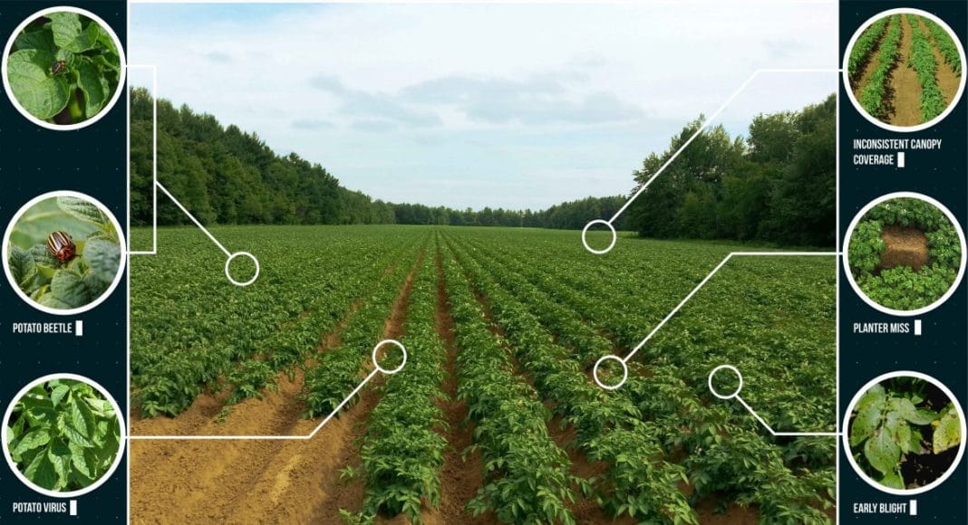
Gaudet notes that NDVI’s or other vegetative indices can also tell us where in the field the crop is stressed. “When we determine the areas of stress, we need to scout these areas to determine the cause,” he says. “We may also take a tissue test to determine nutrient levels in the plant or send a plant sample to the lab for disease testing.”
He adds that remote sensing can also be used to adjust irrigation systems. “It’s quite easy to see from the imagery if adequate coverage is being achieved.”
The third level of remote sensing application, says Zebarth, is more sophisticated hyperspectral imaging. He notes companies are working on this (developing algorithms and training the system to recognize given parameters) as well as academics such as Idaho State University’s Dr. Donna Delparte.
Baleri adds more sophisticated remote sensing application is also being achieved through combining remote sensing data with weather information and soil parameters such as moisture content to create prescription maps. These maps are then used, for example, to help predict yield or decide where and what action should be taken for disease control.
“In potatoes, our analytics modules are able to identify the presence of anomalies such as potato virus Y, late blight and Colorado potato beetle,” he says. “We are focused on data analytics, but we work closely with about 10 data providers and we always verify that the data provided to us is excellent. Sometimes farmers have their own drones. We work in Alberta, Manitoba and New Brunswick for potatoes right now.”
Merits of Satellites, Drone and More
Baleri explains that whether his firm uses data from satellites, drones, airplanes or equipment-mounted systems depends on the client-farmer’s goal.
“We look at the question that needs answering and decide from there,” he says. “Satellite imagery is not the best resolution but it’s fine for ‘big picture’ things like NDVI. Drones at 400 feet provide better resolution, and for a really close look, we can use spot drones or equipment-mounted cameras.”
All three (satellites, drone and low-level camera systems) are being employed in a partnership between Resson and agronomists and growers at McCain Foods. The firm’s North American Director of Agronomy Yves Leclerc says, “we see tremendous potential to continue to improve potato operations through the use of predictive analytic technology, and will continue to partner with Resson and the potato growing community toward the implementation of breakthrough technology applications and advancing agricultural innovation.”
Farooque notes satellite data is also limited in that it might take significant time for a particular satellite to return to a previous position, and that it’s also affected by clouds, temperature and wind.
“Satellite imagery has been used to differentiate bare soil from blueberry plants. We can also use remote sensing to map blueberry fields to see where pesticides should be applied or where drought is hitting,” he says. “I am also working on detection of weeds in soybeans with Andrew McKenzie-Gopsill, but the resolution must be very high for that, so we are using proximal ground-based sensors.”
Farooque notes drone use is picking up because flight height can be adjusted to achieve the resolution needed.
“In potatoes, I am collaborating with P.E.I. Department of Agriculture scientists Evan MacDonald and Kyra Stiles to gather baseline data on stages of crop growth (colour changes in the crop, and ratio of soil:crop) using sensor-equipped drone technology,” he says. “Soil organic matter in potato fields is linked to colour changes that can be detected with a thermal/multispectral camera. This has been shown in other crops and management decisions have been made accordingly, such as adding biosolids in certain parts of the field. P.E.I. soils are dark and so we’ll see how much colour change can be detected this summer. It’s my personal observation that organic matter is declining in P.E.I. soils.”
Zebarth notes there have been many technical challenges in his work with drones, from calibrating the data, finding the right camera system, and creating software that can “stitch” together the images to make larger images. “Now, we can use drone data to calculate NDVI, correlate that to canopy mass and indirectly to yield, track crop development over time and compare fields, predict nutrient demand,” he says. “More stationary satellite-based imagery is becoming available where an image can be taken of a certain field every day, but resolution is still an issue.”
Smith says it is still a challenge with drones to achieve timely acquisition of data and to make sure the data are of good quality. “The use of an incident light sensor with the camera would help ensure that we can correct for differing light conditions and process the data to a quantitative measure of reflectance,” she says. She adds that in looking at drone images, growers “intuitively seem to have an idea why things appear the way they do, and somehow we need to harness that capability to extract more information.”
Future Outlook
In Zebarth’s view, satellite or tractor-mounted sensors are the future “because they’re a lot less work than drones. Satellite firms are set up for large data capture and analysis. I think the future of drones is more that they will do tasks such as drop baits in a corn field.”
For his part, Baleri believes overall it will take several more years to develop fully-automated remote sensing technology, and that growers’ trust in it will grow over time.
“Eventually, we will connect our analytics with equipment-makers so that remote sensing will lead to automatic adjustment of application of things like fertilizer or fungicide,” he says. “We’ll see remote sensing enabling increased efficiency and productivity, enabling the taking of action before things become a real issue and also controlling input costs.”
Baleri says Resson’s goal is to provide $3 payback for each $1 spent on remote sensing by farmers. “As it’s scaled up to more acres and more companies, that will happen,” he says. “It’s the same as precision ag tech, which has become more affordable as time goes on.”
Farooque agrees that in future remote sensing data will be linked with farm equipment (via Bluetooth or satellite) so that management practices can be adjusted on the fly. “It’s like any other technology,” he says. “We’ve gone from computers that took up whole rooms to computers in our cell phones. Hardware and software will evolve with the time, and a few years down the road we will see how useful remote sensing will be for agriculture.”
He and his team have received a research grant from Canadian Space Agency to design and develop a tiny satellite to be launched in Atlantic Canada, with a platform specifically for agriculture.
Gaudet notes remote sensing is not intended to solve all the problems in a field, but another tool to use to help make management decisions on farms.
“The next step for remote sensing in agriculture is to determine the underlying issue causing crop stress,” he says. “It could be caused by a nutrient deficiency in the plant or in the soil, drought stress, insect pressures or caused by a disease. Current research at A&L Labs is helping to determine the underlying cause, such as developing nitrogen models to estimate N status throughout the field. The technology to apply variable-rate N across a field is out there and we need to make use of it.”
In Smith’s view, the future development of hyperspectral sensors may help differentiate different stresses, but to date these sensor systems are expensive. She adds the use of thermal and microwave sensors systems may some day also assist in providing complementary information to multispectral and hyperspectral sensor systems.