SWAT MAPS are a digital map which charts soil, water and topography in fields in order to help growers better understand their fields.
Experts


Editor’s note: This interview has been edited for length and clarity.
Spud Smart (SS): Why should growers care about getting a SWAT MAP made?
Evan MacDonald (EM): As far as precision ag and potatoes goes, I think they’re a prime candidate for doing a lot of this work. They’re a really expensive crop to grow and require a lot of inputs. So, even marginal gains or marginal savings and fertility or small gains in yield can add up to a lot in something like potatoes, whereas if it’s a lesser value crop, those 10 per cents, and five per cents don’t mean as much. When you’re dealing with something that costs $3,000 an acre to grow or more, that can really add up.
A lot of growers are already doing things like grid sampling for variable rate, fertility prescriptions, which I think is great. Anytime you can take into account the differences in your field and try and manage them, it’s a good thing… But SWAT can really help to target those prescriptions by managing those differences in soil, water and topography.
Wes Anderson (WA): There’s a lot of things that ultimately affect the yield variability across the field… Insects, diseases, all those typical pests, and all different crops can affect those things. Things like compaction, even a one-year whoops like spray drift, or maybe issues with the planter that affects plant population. There’s a lot a lot of different things. And with SWAT MAPS, we try and focus on the stable soil and water properties that really don’t change necessarily from year to year.
SS: How is a SWAT MAP made?
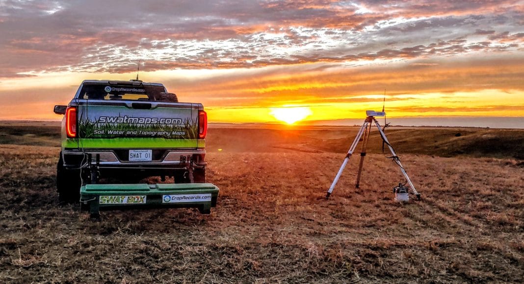
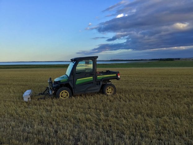
WA: What we typically do would be to go out simply in a half ton truck, and we have this thing in the back that’s called a SWAT BOX. Within that SWAT BOX is a device that measures electrical conductivity, so it might be an EM38, which is device that’s actually been around a very long time in Canada, or in some cases, it might be a Topsoil Mapper. But either way, it’s measuring the electrical conductivity of the soil at a couple different depths, which is related to solutes in the soil, it’s related to moisture, it’s related to texture, which again are somewhat all interrelated with each other. But at the end of the day, it’s a really good tool for delineating salt gradients and soil texture.
We also collect elevation data, very accurate RTK elevation, so either collected at the time in the field, or can get it through LIDAR or other sources. And we create topography and waterflow and accumulation models from that, that can also go into the final SWAT MAP. The final SWAT MAP can be combination of multiple layers that ultimately the goal is to depict the dominant variable characteristics in the field.
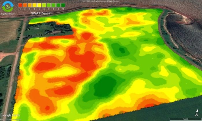
SS: What are management zones?
WA: The number one thing is you’ve got to get the management zones right, which means you have to group areas together that have similar response characteristics for the treatment you’re talking about.
Now, if we’re talking about say sulfur responsiveness, we want to get zones that sort of determine where the most responsive soils to sulfur are, and where the least responsive soils to sulfur are, and maybe some gradients in between. If it’s a fungicide, for example, it might simply be something as simple as an on off where there is very poor crop or no crop that doesn’t justify a fungicide versus a good crop that does need a fungicide.
SS: What can management zones tell you about soil conditions in a field?
WA: A SWAT MAP is actually different for every field. A zone 10 in one field is not the same as a zone 10 in another field, but it’s just a general framework. And I always say the best way to think about it is really in the context of water, your zone one should generally always the driest, zone 10, the wettest.
EM: Zone or grid sampling can be used in conjunction with SWAT zones to build prescriptions. Some of the common ones for fertility for things like potash and mag and lime being spread. I’ve even had a lot of interest in doing things like manure and soil amendment applications targeting certain parts of the field that may need that a little bit more than others.
Variable rate planting I think has a lot of promise. A lot of growers have the capability on their planters to adjust the spacing and a good base of information is a SWAT MAP. It’s not just meant for potatoes; it can be used for the other crops in the rotation as well.
SS: Should you ever take a management zone out of crop production?
WA: Yield is really a dynamic thing that can vary year to year depending on rainfall, frankly. Yields don’t necessarily have a linear correlation to the SWAT zones, sometimes they do.
For example, this past year in northern Alberta, we were extremely wet. And so, zone one, typically the driest zone, rarely the highest yielding, was actually the highest yielding zone in the bulk of my client’s fields. Whereas zone 10, actually zone seven through 10 were completely flooded out. Traditionally, zone seven and eight would actually be a really high yielding zone. Again, it does really depend on the area, depends on the rainfall, depends on the field and depends on the factors affecting yield.
EM: I think it comes down to not all zone ones are created equal. If it’s a field that’s had a particularly hard time with erosion, even on a wet year, and I’ve seen it on irrigated fields even, there’s differences in those zone ones to the lower areas. Like the areas that just have that thin layer of topsoil and not a whole lot of ability to hold on to any nutrients or moisture, they do seem to struggle a little bit more.
I think in some cases, we need to consider things like that. In some places you already see it. Where knolls or high sloped areas that were almost scalped of topsoil, they’re just not planted anymore. I think there’s potential there to look at doing things like using soil building crops in those areas.
SS: How can you use the data SWAT MAPS provides to improve soil quality?
WA: The real power and value behind SWAT MAPS in a lot of fields would be really the ability to interpret and predict better nutrient availability and mineralization, and therefore nutrient response in different parts of the field.
In this part of the world here, we get these high organic matter depressions that can supply a lot of nutrients, and in particular nitrogen, they’re just always mineralizing a lot of nutrients, and we can actually afford to cut back even though they still have really good deal potential. You don’t need to really put on a lot of fertilizer in those places.
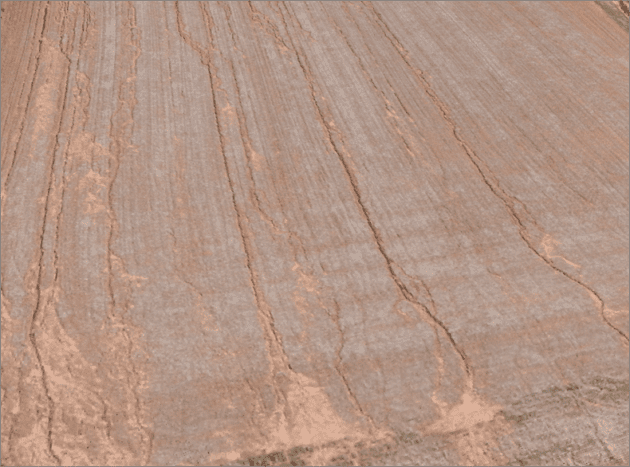
EM: This is just an example of about a one-acre section of land here, I think this was bean stubble actually. This is a photo from a 3D model captured with a drone. There are about 50 tons of topsoil loss on that one-acre section of land with that rill and gully erosion, which in the springtime after the snowmelt here, is not totally uncommon.
If there were no erosion going forward, it would take nearly 20 years to get that topsoil back, just to give you an idea how long it does take to get it back, and that’s probably an optimistic look at it. I’ve heard other views say it takes 100 to 500 years to grow an inch of topsoil. And then in addition to that, scientists from the University of Wisconsin saying that fertilizer value in a ton of topsoil is about $13 a tonne.
We often think of soil erosion as an environmental issue, but really, it’s an economic issue too. And with soil leaving the field or leaving even the place that it was in the field, production is going with that as well. It’s great to see that farmers are taking this stuff seriously and doing a good job of mitigating it in the future.
SS: Do you need to get the SWAT MAPS of your fields redone every so many years?
WA: You shouldn’t need to would be my typical answer. SWAT MAPS are based on really stable attributes of the soil. Unless there has been a lot of drainage ditches done, earthmoving, that sort of thing, physically changing the landscape, there shouldn’t really be any need to remap a field.
Crop Pro Consulting has been utilizing SWAT MAPS for I think well over 10 years in Saskatchewan at least. A lot of those fields, we’re still using the same SWAT MAP today, and it still reflects the soil variability in the field.
EM: That’s kind of what I expect around here, too. Those soil properties aren’t changing, so we wouldn’t need to make a new SWAT MAP. The strategy is to have your SWAT MAP done. Then normally around here the process is, if someone does do soil sampling, usually it’s in the year before potatoes. So, then you keep doing your soil sampling, and you can use your SWAT MAP to target your prescriptions to be more accurate.
For more information on SWAT MAPS watch our latest webinar about it.